The times has changed. Now it is easier for men-kind to go at as much height in sky like journey on Moon, Mars etc. But there was time even the best quality of aeroplanes could achieve as much as height as it could. But here is adventurous story of April 04, 1933 from the Achieves of The Guardian when the world's highest mountain has surrendered to aeroplanes, circling 100 feet above the summit. Before I put the essay of the Guardian as written and reported, I must mention some of the backgrounds of beautiful Himalaya mountain range including the MOUNT EVEREST in Asia.
In SANSKRIT language and literature, HIMALAYA has been called-HIMA (snow) + ALAYA (dwelling). means 'dwelling of snow' . This HIMALAYA, with some of the highest peaks including the height of the MOUNT EVEREST, in Asia is the youngest, highest and the longest mountain range in the world. It criss-crises five countries of the PLANET-Bhutan, Nepal,, India, China and Pakistan. Significantly, the Himalayan mountain range is youngest mountain range in the globe because rick are yet to be formed. Still there are lot of sand and soils mounds in the mountain range. Because of large scale of forest denunciation , recurring threats of floods have made life miserable in parts of Bihar and Uttar Pradesh in India . Soil and sands are flowing during flood period from various rivers, originating from Nepal, mainly because of large -scale forest cuttings of trees in forest range , specially in Nepal areas. It spreads plans of the Indian sub-continent from Tibetan plateau. The range runs west-north ward to the east-south east., about 24 km long. Not only that Himalaya mountain rage incorporates 100 mountains exceeding 7200 meters or over 23600 ft. height. Several places in the Himalaya mountain range have religious significances in Hinduism, Islam, Jainism, Sikhism and Buddhism. In Hinduism, the Himalaya has been personified as the GOD-HEMANT, the god of snow, who is mentioned in the Hindu mythological books and scriptures like GEETA. HEMAN, the god of snow, was father of GANGA and SARSWATI , the most pious and well-known rivers in India !
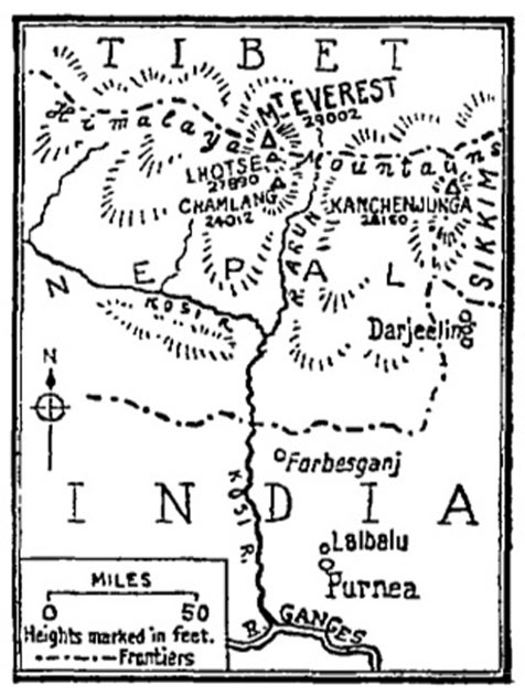
NO doubt many mountaineers have succeeded in conquering Himalaya's MOUNT EVEREST, in the last 25 to 30 years, the journey of HIMALAYA including mount-Everest by the Houston Everest Expedition on April 03, 1933 was wonderful historically as reported in the issue of the Guardian- "From Archive , 4 April 1933: EVEREST conquered from the air." The story of The Guardian, apart from mentioning many significant aspects of the conquering of Himalaya's Everest, has pin-pointed one of the oldest airbases -PURNIA in BIhar and FORBESGANJ in BIHAR for meticulating planning and taking off the related planes to conquer the MOUNT EVEREST. The mission was "full of thrills and passive dangers". Lord Clydesdale, Colonel Blacker and the Flight Lieutenant Mcintyre had been team members of the Westland planes expedition .The Guardian has also referred the wonderful and experienced role Indian meteorological officer of Purnea S N Gupta, whose information and advice about weather on April 03, 1933 had been of great value.
Just I a reproducing below The Guardian report about Everest Conquering :-
From the archive, 4 April 1933: Everest conquered from the air
The world's highest mountain has surrendered to aeroplanes circling 100 feet above its summit

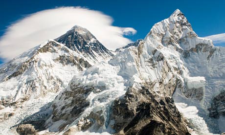
Mount Everest. Photograph: Image Source/Corbis
"Mount Everest has been flown over." The laconic message, received last night, announces that the Houston Everest expedition has met with complete success and that the world's highest mountain has surrendered to the all-conquering aeroplane.
Lord Clydesdale, Colonel Blacker, and Flight Lieutenant McIntyre set off early yesterday in the Westland planes on what was intended to be a trial flight. But the wind conditions turned out to be so favourable that they went on to Everest, circled the summit at a hundred feet above it, and were safely back again at Purnea soon after eleven. It is a splendid achievement, and hearty congratulations must go out to the airmen and to all who have made it possible. It is a splendid achievement - not for any material gains, any additions to aeronautical knowledge that it brings, for it brings few or none, but simply because it was one of the few last great spectacular flights in aviation which remained to be done.
No one would attempt to compare these three brief hours of adventure, full of thrills and passive dangers, with the long months of arduous physical toil which those must endure who attempt to conquer Everest by land, in the old way of the mountaineer. But to assert man's mastery of the air by flying over the roof of the world must make its strong appeal to everyone's imagination, none the less. What strange account will the adventurers have brought back of Everest and its great south face as no living eye has seen it? What strange photographs and film record may they have obtained - obtained for the rest of us to share - of the unknown Himalayas, looked at from a height higher than bird has ever gone?
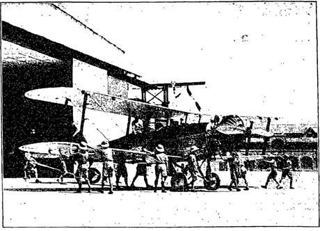
 One of the two aeroplanes which have flown over Everest, photographed at Karachi. The summit of Everest was flown over to-day by both machines of the Houston Everest Expedition. The following official report has been drawn up by Squadron Leader Lord Clydesdale:
"This morning (April 3) the Indian meteorological officer at Purnea, Mr. S. N. Gupta, whose information and advice has been of very great value to the expedition, reported from balloon observations that the wind, which previously had been unsuitable, had dropped to a velocity of 57 m.p.h. at 33,000 feet which altitude we had decided would be the most suitable working height for a photographic survey. Our two machines took off at 8 25 from Lalbalu Aerodrome in still air. The Houston-Westland plane contained Colonel Blacker and myself, and the Westland-Wallace, piloted by Flight Lieutenant McIntyre, with Mr. S. R. Bonnett, who is the aerial photographer, as observer.
"Our direct route to the summit meant flying on track 342 degrees. This necessitated changing the compass course at intervals more to the west on account of increased wind velocity with height according to our weather report. We had relied on overcoming to some extent the difficulty of accurate compass navigation caused by this frequent change of wind speed by the good landmarks near and along our track.
"A heavy dust haze rising to a considerable height almost completely obscured the ground from Forbesganj to the higher mountain ranges. This made aerial survey work impossible. We climbed slowly at low engine revolutions to a height of 10,000 feet. By this height the crews of both machines had tested their respective electrical heating sets, and McIntyre and I signalled to each other that everything was satisfactory. After 30 minutes' flying we passed over Forbesganj, our forward emergency landing ground forty miles from Purnea, and at a height of 19,000 feet Everest first became visible above the haze."
Click here for the full report.

Lord Clydesdale, Colonel Blacker, and Flight Lieutenant McIntyre set off early yesterday in the Westland planes on what was intended to be a trial flight. But the wind conditions turned out to be so favourable that they went on to Everest, circled the summit at a hundred feet above it, and were safely back again at Purnea soon after eleven. It is a splendid achievement, and hearty congratulations must go out to the airmen and to all who have made it possible. It is a splendid achievement - not for any material gains, any additions to aeronautical knowledge that it brings, for it brings few or none, but simply because it was one of the few last great spectacular flights in aviation which remained to be done.
No one would attempt to compare these three brief hours of adventure, full of thrills and passive dangers, with the long months of arduous physical toil which those must endure who attempt to conquer Everest by land, in the old way of the mountaineer. But to assert man's mastery of the air by flying over the roof of the world must make its strong appeal to everyone's imagination, none the less. What strange account will the adventurers have brought back of Everest and its great south face as no living eye has seen it? What strange photographs and film record may they have obtained - obtained for the rest of us to share - of the unknown Himalayas, looked at from a height higher than bird has ever gone?
 One of the two aeroplanes which have flown over Everest, photographed at Karachi. The summit of Everest was flown over to-day by both machines of the Houston Everest Expedition. The following official report has been drawn up by Squadron Leader Lord Clydesdale:
"This morning (April 3) the Indian meteorological officer at Purnea, Mr. S. N. Gupta, whose information and advice has been of very great value to the expedition, reported from balloon observations that the wind, which previously had been unsuitable, had dropped to a velocity of 57 m.p.h. at 33,000 feet which altitude we had decided would be the most suitable working height for a photographic survey. Our two machines took off at 8 25 from Lalbalu Aerodrome in still air. The Houston-Westland plane contained Colonel Blacker and myself, and the Westland-Wallace, piloted by Flight Lieutenant McIntyre, with Mr. S. R. Bonnett, who is the aerial photographer, as observer.
"Our direct route to the summit meant flying on track 342 degrees. This necessitated changing the compass course at intervals more to the west on account of increased wind velocity with height according to our weather report. We had relied on overcoming to some extent the difficulty of accurate compass navigation caused by this frequent change of wind speed by the good landmarks near and along our track.
"A heavy dust haze rising to a considerable height almost completely obscured the ground from Forbesganj to the higher mountain ranges. This made aerial survey work impossible. We climbed slowly at low engine revolutions to a height of 10,000 feet. By this height the crews of both machines had tested their respective electrical heating sets, and McIntyre and I signalled to each other that everything was satisfactory. After 30 minutes' flying we passed over Forbesganj, our forward emergency landing ground forty miles from Purnea, and at a height of 19,000 feet Everest first became visible above the haze."
Click here for the full report.

No comments:
Post a Comment